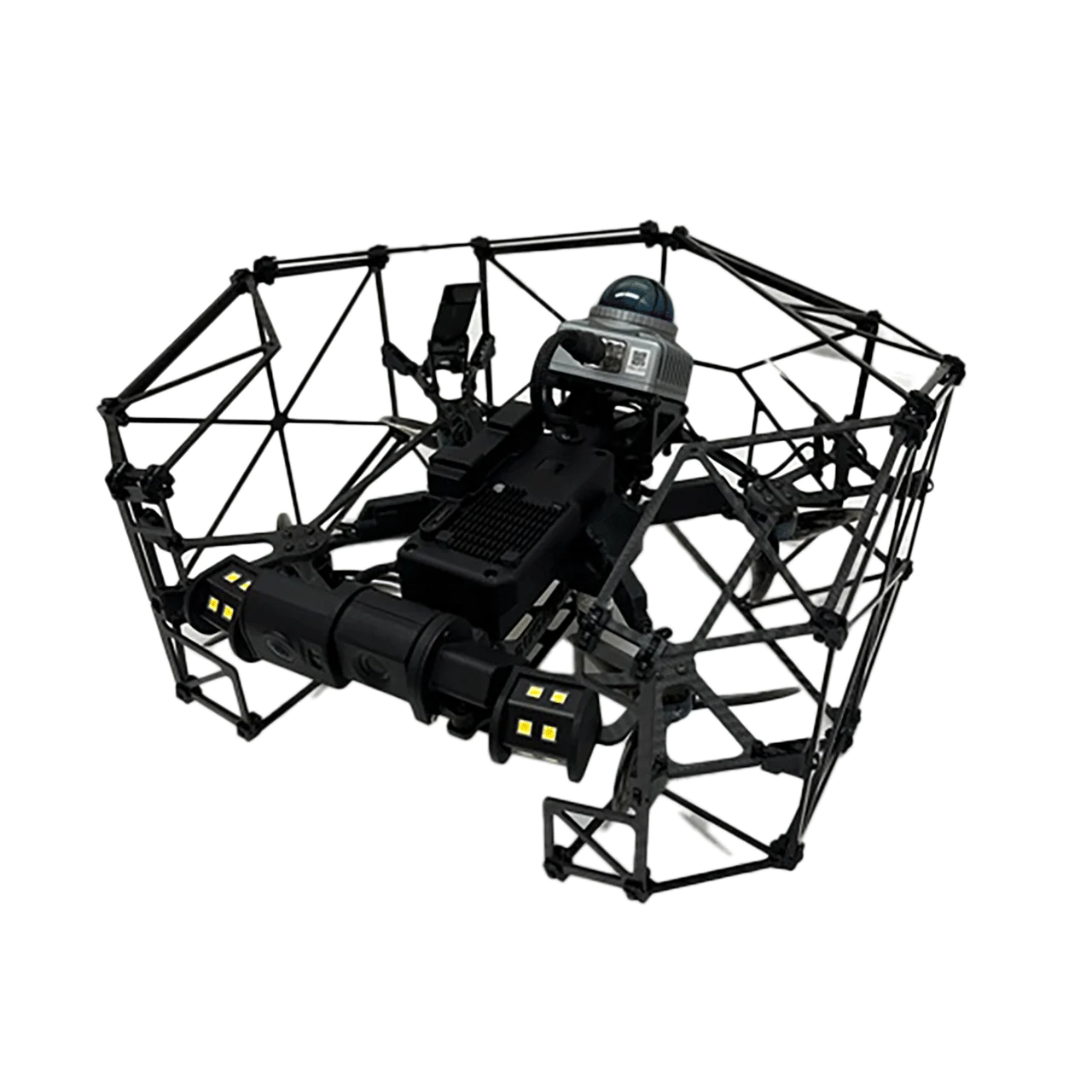
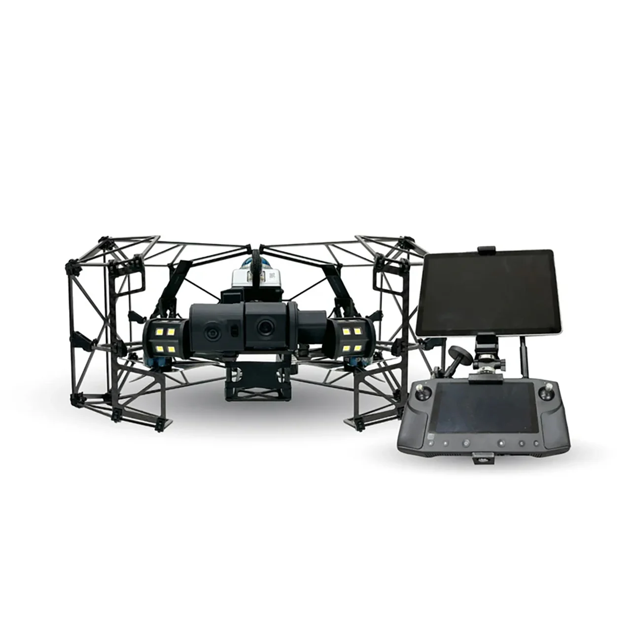
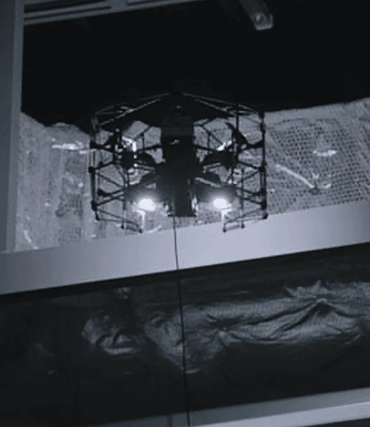
Terra Xross 1 is an indoor inspection drone with integrated LiDAR navigation, 4K 180° tilt camera, 10,480 lumen LED illumination, and optional tethered power system — purpose-built for safe, stable flight in GPS-denied, dusty, and pitch-dark confined spaces. Weighing just 1.8 kg (360×310×210 mm) with a protective cage design, the Terra Xross 1 makes challenging indoor environments accessible to any operator, offering simplicity, safety, and affordability for tank inspection, ship interior survey, chimney and boiler assessment, underground mine mapping, and plant equipment monitoring.
Simple Flying — The New Standard for Indoor Drones
Terra Drone designed the Terra Xross 1 to make indoor drone operations accessible to everyone. LiDAR-based positioning combined with visual odometry ensures steady hovering and stable flight — even in dusty, dark, or featureless environments where GPS and visual references are unavailable. No specialized pilot skills are required; the system handles stabilization autonomously so operators can focus on the inspection task.
LiDAR Navigation — Stable in Any Condition
- LiDAR + Visual Odometry Fusion – Autonomous stabilization in GPS-denied, dark, dusty, and featureless indoor environments
- 40 m Range @10% Reflectivity / 70 m @80% – Reliable distance sensing across varied surface conditions
- 200,000 Points/Second, 10 Hz Frame Rate – Dense real-time point cloud for environmental awareness
- 2 cm Precision @10 m – Survey-grade accuracy for mapping and 3D reconstruction
- Class 1 Laser Safety – Eye-safe for operation around personnel
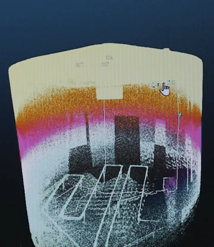
Safe BVLOS Flight with Real-Time 3D Data
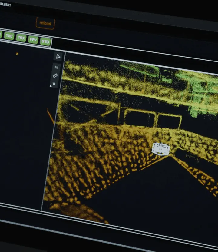
Real-time 3D mapping provides operators with live situational awareness during Beyond Visual Line of Sight (BVLOS) operations. The LiDAR point cloud builds a 3D model of the environment as the drone flies, ensuring safe navigation around obstacles, pipes, structural elements, and other hazards — even when the pilot cannot see the drone directly.
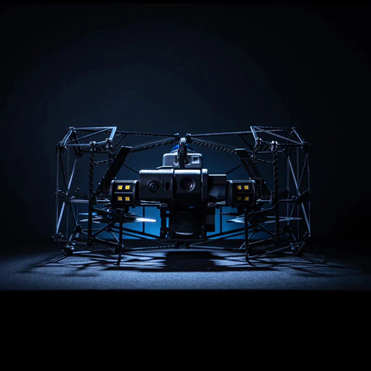
4K 180° Tilt Camera with LED Lighting
- 4K Video (3840×2160) at 25 fps – High-resolution inspection footage for detailed analysis
- 1/1.7″ Sensor, 8 MP – Clear imaging in low-light confined environments
- 180° Vertical Tilt – Inspect both above and below the aircraft, including ceilings, overhead pipes, and floor surfaces
- 10,480 Lumens LED Illumination – Ultra-bright lighting ensures clear, vivid footage in complete darkness
Tethered Power System — Unlimited Flight Duration
The optional tethered power module provides a constant external power supply, enabling continuous, uninterrupted flight for long-duration inspections. This eliminates the risk of battery exhaustion and removes the need for battery swaps during critical interior survey missions — essential for large tanks, complex manufacturing plants, and underground mine mapping.
- Standard Battery Flight: ~10 minutes
- Tethered Flight: Unlimited continuous operation
Terra Xross Cloud — 3D Data Management
Terra Xross Cloud allows operators to associate captured images and videos with 3D point cloud data for intuitive, location-based management. The cloud platform facilitates teamwork, data sharing with customers, and collaborative review — streamlining the entire inspection workflow from data capture to deliverable reporting.
Protective Cage — Safe for Confined Spaces
- Built-in Protective Cage – Prevents rotor contact with walls, pipes, and structural elements during close-proximity flight
- 1.8 kg Total Weight (incl. battery) – Ultra-lightweight for single-person transport and deployment
- 360 × 310 × 210 mm Compact Dimensions – Fits through manholes, hatches, and confined entry points
Flight Performance
- Max Speed: 2.5 m/s
- Wind Resistance: 3 m/s
- Operating Temperature: 0°C to 45°C
Trusted by Global Industry Leaders
The Terra Xross platform is trusted by leading organizations across the energy and industrial sectors, including Shell, BP, ExxonMobil, Vopak, TotalEnergies, LyondellBasell, VTTI, and BASF — deployed across the Terra Drone Group’s global inspection operations.
Inspection & Mapping Applications
- Tank Inspection – Interior assessment of storage tanks (oil, gas, chemical, water) without confined space entry
- Ship Interior Survey – Cargo hold, ballast tank, and engine room inspection
- Chimney & Boiler – Vertical shaft inspection using 180° tilt camera
- Underground Mine Mapping – 3D point cloud mapping of mine tunnels and cavities
- Plant Equipment Monitoring – Overhead pipe rack, pressure vessel, and structural condition assessment